Four Western Pacific island nations–Marshall Islands, Micronesia, Nauru and Palau–are true friends of Israel, typically standing with the Jewish state against the spate of anti-Israel resolutions which are staples of the United Nations and its automatic pro-Palestinian majority.
In appreciation for these steadfast friends of Israel, San Diego Jewish World introduces today a new ongoing feature, providing news and tourism information about Nauru, Palau, Micronesia and Marshall Islands. Our hope is that world travelers will see fit to visit those countries that are consistent friends of Israel.
First we’ll begin with some basic information about the four countries as provided by Wikipedia.
*
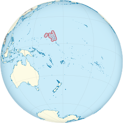
The Marshall Islands, officially the Republic of the Marshall Islands (Marshallese: Aolepān Aorōkin M̧ajeļ),[note 1] is an island country located near the equator in the Pacific Ocean, slightly west of the International Date Line. Geographically, the country is part of the larger island group of Micronesia. The country’s population of 53,158 people (at the 2011 Census) is spread out over 29 coral atolls,[2] comprising 1,156 individual islands and islets. The islands share maritime boundaries with the Federated States of Micronesia to the west, Wake Island to the north,[note 2] Kiribati to the south-east, and Nauru to the south. About 27,797 of the islanders (at the 2011 Census) live on Majuro, which contains the capital.[2]
Micronesian colonists gradually settled the Marshall Islands during the 2nd millennium BC, with inter-island navigation made possible using traditional stick charts. Islands in the archipelago were first explored by Europeans in the 1520s, with Spanish explorer Alonso de Salazar sighting an atoll in August 1526. Other expeditions by Spanish and English ships followed. The islands derive their name from British explorer John Marshall, who visited in 1788. The islands were historically known by the inhabitants as “jolet jen Anij” (Gifts from God).[3]
The European powers recognized Spanish sovereignty over the islands in 1874. They had been part of the Spanish East Indies formally since 1528. Later, Spain sold the islands to the German Empire in 1884, and they became part of German New Guinea in 1885. In World War I the Empire of Japan occupied the Marshall Islands, which in 1919 the League of Nations combined with other former German territories to form the South Pacific Mandate. In World War II, the United States conquered the islands in the Gilbert and Marshall Islands campaign. Along with other Pacific Islands, the Marshall Islands were then consolidated into the Trust Territory of the Pacific Islands governed by the US. Self-government was achieved in 1979, and full sovereignty in 1986, under a Compact of Free Association with the United States. Marshall Islands has been a United Nations member state since 1991.

Politically, the Marshall Islands is a presidential republic in free association with the United States, with the US providing defense, subsidies, and access to U.S. based agencies such as the FCC and the USPS. With few natural resources, the islands’ wealth is based on a service economy, as well as some fishing and agriculture; aid from the United States represents a large percentage of the islands’ gross domestic product. The country uses the United States dollar as its currency.
The majority of the citizens of the Marshall Islands are of Marshallese descent, though there are small numbers of immigrants from the United States, China, Philippines and other Pacific islands. The two official languages are Marshallese, which is a member of the Malayo-Polynesian languages, and English. Almost the entire population of the islands practises some religion, with three-quarters of the country either following the United Church of Christ – Congregational in the Marshall Islands (UCCCMI) or the Assemblies of God.
*
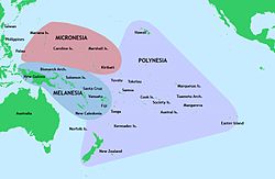 Micronesia (from Greek: μικρός, mikrós, “small” + Greek: νῆσος, nêsos, “island”) is a subregion of Oceania, comprising thousands of small islands in the western Pacific Ocean. It has a shared cultural history with two other island regions, Polynesia to the east and Melanesia to the south.
The region has a tropical marine climate, and is part of the Oceania ecozone. There are four main archipelagos along with numerous outlying islands.
Micronesia is divided politically among several sovereign countries. One of these is the Federated States of Micronesia, which is usually also called “Micronesia” for short and is not to be confused with the overall region. Aside from the Federated States of Micronesia, the Micronesia region encompasses four other sovereign, independent nations—Kiribati, Marshall Islands, Nauru, and Palau—as well as three U.S. territories—Guam, Northern Mariana Islands, and Wake Island.
Micronesia began to be settled several millennia ago, although there are competing theories about the origin and arrival of the first settlers.[1] The earliest known contact with Europeans occurred in 1521, when Ferdinand Magellan reached the Marianas. The coinage of the term “Micronesia” is usually attributed to Jules Dumont d’Urville’s usage in 1832, however Domeny de Rienzi had used the term a year previously.
*
Nauru (/nɑːˈuːruː/ nah-oo-roo or /ˈnɑːruː/ nahr-oo[4][5][6]), officially the Republic of Nauru (Nauruan: Repubrikin Naoero) and formerly known as Pleasant Island, is an island country in Micronesia in the Central Pacific. Its nearest neighbour is Banaba Island in Kiribati, 300 kilometres (186 mi) to the east. With 9,488 residents in a 21-square-kilometre (8.1 sq mi) area, Nauru is the smallest state in the South Pacific and third smallest state by area in the world, behind only Vatican City and Monaco.
Settled by native peoples from Micronesia and Polynesia, Nauru was annexed and claimed as a colony by the German Empire in the late 19th century. After World War I, Nauru became a League of Nations mandate administered by Australia, New Zealand and the United Kingdom. During World War II, Nauru was occupied by Japanese troops, who were bypassed by the Allied advance across the Pacific. After the war ended, the country entered into UN trusteeship. Nauru gained its independence in 1968.
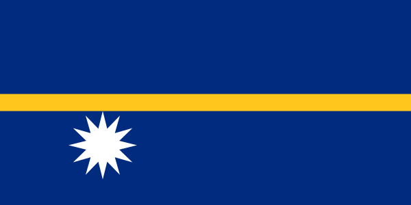
Nauru is a phosphate rock island with rich deposits near the surface, which allowed easy strip mining operations. It has some remaining phosphate resources which, as of 2011, are not economically viable for extraction.[7] Nauru boasted the highest per-capita income enjoyed by any sovereign state in the world during the late 1960s and early 1970s. When the phosphate reserves were exhausted, and the island’s environment had been seriously harmed by mining, the trust that had been established to manage the island’s wealth diminished in value. To earn income, Nauru briefly became a tax haven and illegal money laundering centre. From 2001 to 2008, and again from 2012, it accepted aid from the Australian Government in exchange for hosting the Nauru detention centre. As a result of heavy dependence on Australia, many sources have identified Nauru as a client state of Australia.[8][9][10][11]
The president of Nauru is Baron Waqa, who heads a 19-member unicameral parliament. The country is a member of the United Nations, the Commonwealth of Nations, the Asian Development Bank and the Pacific Islands Forum. Nauru also participates in the Commonwealth and Olympic Games. Recently Nauru became a member country of the International Renewable Energy Agency (IRENA).
*
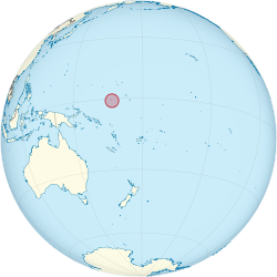
Palau (Listeni/pəˈlaʊ/, historically Belau or Pelew), officially the Republic of Palau (Palauan: Beluu er a Belau),[4] is an island country located in the western Pacific Ocean. The country’s population of around 21,000 is spread across 250 islands, which form the western chain of the Caroline Islands in Micronesia. The most populous of these is Koror. The capital Ngerulmud is located on the nearby island of Babeldaob, in Melekeok State. Palau shares maritime boundaries with Indonesia, the Philippines, and the Federated States of Micronesia.
The country was originally settled approximately 3,000 years ago by migrants from the Philippines and sustained a Negrito population until around 900 years ago. The islands were first explored by Europeans in the 16th century, and were made part of the Spanish East Indies in 1574. Following Spain’s defeat in the Spanish–American War in 1898, the islands were sold to Imperial Germany in 1899 under the terms of the German–Spanish Treaty, where they were administered as part of German New Guinea. The Imperial Japanese Navy conquered Palau during World War I, and the islands were later made a part of the Japanese-ruled South Pacific Mandate by the League of Nations. During World War II, skirmishes, including the major Battle of Peleliu, were fought between American and Japanese troops as part of the Mariana and Palau Islands campaign. Along with other Pacific Islands, Palau was made a part of the United States-governed Trust Territory of the Pacific Islands in 1947. Having voted against joining the Federated States of Micronesia in 1979, the islands gained full sovereignty in 1994 under a Compact of Free Association with the United States.
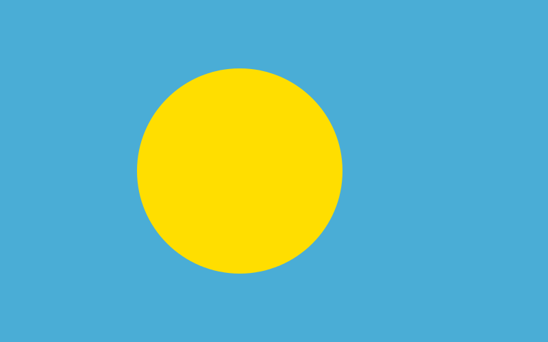
Politically, Palau is a presidential republic in free association with the United States, which provides defense, funding, and access to social services. Legislative power is concentrated in the bicameral Palau National Congress. Palau’s economy is based mainly on tourism, subsistence agriculture and fishing, with a significant portion of gross national product (GNP) derived from foreign aid. The country uses the United States dollar as its currency. The islands’ culture mixes Japanese, Micronesian and Melanesian elements. The majority of citizens are of mixed Micronesian, Melanesian, and Austronesian descent, with significant groups descended from Japanese and Filipino settlers. The country’s two official languages are Palauan (member of the wider Sunda–Sulawesi language group) and English, with Japanese, Sonsorolese, and Tobian recognized as regional languages.
*
Preceding provided by Wikipedia